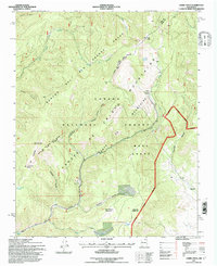
1995 Map of Cerro Vista
USGS Topo · Published 1997About this map
Rancho del Rio Grande Grant and Mora Grant define the land management patterns across this high-altitude section of the Sangre de Cristo Mountains. The topography is dominated by peaks such as Cerro Vista, Cerro Olla, and Cerro del Oso, with the landscape deeply carved by Sardinas Canyon and Arellano Canyon. Historically significant land grants meet here at the Taos and Mora County line, showcasing a complex intersection of private grant boundaries and Carson National Forest administration.
Find a feature on this map
37 named features on this map. Tap any name to fly to it.
Don’t see what you’re looking for? This feature index may not catch every label — zoom into the map to look around manually.
Map Details
Editions of this 1995 Cerro Vista Map
This is the sole edition of this map. No revisions or reprints were ever made.
Other maps of this area

1954 · Raton
USGS Topo · 1:250,000

1958 · Raton
USGS Topo · 1:250,000

1964 · Tres Ritos
USGS Topo · 1:24,000

1964 · Ranchos De Taos
USGS Topo · 1:24,000
1964 · Jicarita Peak
USGS Topo · 1:24,000

1965 · Osha Mountain
USGS Topo · 1:24,000

1965 · Chacon
USGS Topo · 1:24,000

1965 · Holman
USGS Topo · 1:24,000

1965 · Shady Brook
USGS Topo · 1:24,000
1965 · Comanche Peak
USGS Topo · 1:24,000