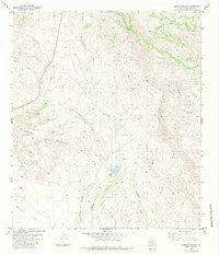
1983 Map of Cerros Prietos
USGS Topo · Published 1983About this map
Cerros Prietos dominates the western portion of this high-desert landscape in Presidio County, where the topography transitions into the expansive Bunton Flat to the southwest. The area is defined by a complex network of drainage systems, most notably Cienega Creek and its many tributaries, which reveal the hydraulic patterns of this arid environment. Human activity is sparsely marked by isolated points of water management and habitation, including Pool Dam and the Laks Ranch settlement.
Find a feature on this map
12 named features on this map. Tap any name to fly to it.
Don’t see what you’re looking for? This feature index may not catch every label — zoom into the map to look around manually.
Map Details
Editions of this 1983 Cerros Prietos Map
This is the sole edition of this map. No revisions or reprints were ever made.
Other maps of this area

1895 · Marfa
USGS Topo · 1:125,000

1896 · Shafter
USGS Topo · 1:125,000

1959 · Presidio
USGS Topo · 1:250,000

1959 · Marfa
USGS Topo · 1:250,000

1965 · Presidio
USGS Topo · 1:250,000

1965 · Marfa
USGS Topo · 1:250,000

1983 · Shafter
USGS Topo · 1:24,000

1983 · Plata
USGS Topo · 1:24,000

1983 · Cuesta Del Burro East
USGS Topo · 1:24,000
1983 · Frenchman Hills
USGS Topo · 1:24,000