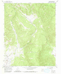
1965 Map of Chacon
USGS Topo · Published 1980About this map
The Mora River valley in northern New Mexico reveals a landscape of high-altitude ranching and small Spanish-American settlements in the mid-1960s. The village of Chacon serves as the primary hub at the southwestern edge of the sheet, nestled where the valley opens between the Rincon Mountains and the dense timber of the Carson National Forest. This area is defined by a series of steep drainages, including Lujan Canyon and Williams Canyon, which feed into the valley floor. Genealogy researchers will find significant detail in the placement of the El Rito Cem and San Antonio Cem near the settlement of San Antonio, reflecting the deep-rooted family histories of the canyon. The map shows the transition from the irrigated valley floors to the high timberline, with numerous Jeep Trails and unnamed ranch roads winding through the canyons of Mora County.
Find a feature on this map
24 named features on this map. Tap any name to fly to it.
Don’t see what you’re looking for? This feature index may not catch every label — zoom into the map to look around manually.
Map Details
Editions of this 1965 Chacon Map
2 editions found
Other maps of this area

1954 · Raton
USGS Topo · 1:250,000

1956 · Tooth Of Time
USGS Topo · 1:62,500

1958 · Raton
USGS Topo · 1:250,000

1965 · Osha Mountain
USGS Topo · 1:24,000

1965 · Chacon
USGS Topo · 1:24,000

1965 · Holman
USGS Topo · 1:24,000

1965 · Shady Brook
USGS Topo · 1:24,000
1965 · Comanche Peak
USGS Topo · 1:24,000
1965 · Cerro Vista
USGS Topo · 1:24,000

1966 · Guadalupita
USGS Topo · 1:24,000