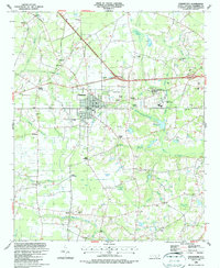
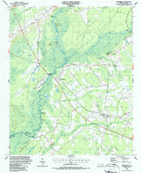
1986 Map of Chadbourn
USGS Topo · Published 1987About this map
Chadbourn serves as the focal point of this Columbus County landscape, defined by the intersection of the CSX railroad and several primary highways. The terrain is a complex mosaic of Carolina bays and wetlands, including Hell Cat Bay, Fivemile Bay, and Dunn Swamp, which have historically shaped the settlement patterns of small communities like Grist and Wards. To the east of the town center, the Southeastern Community College campus and Hughes Airport mark the expansion of infrastructure into the surrounding pinelands.
Find a feature on this map
62 named features on this map. Tap any name to fly to it.
Don’t see what you’re looking for? This feature index may not catch every label — zoom into the map to look around manually.
Map Details
Editions of this 1986 Chadbourn Map
This is the sole edition of this map. No revisions or reprints were ever made.
Other maps of this area

1943 · Nakina
USGS Topo · 1:24,000

1953 · Chadbourn
USGS Topo · 1:62,500

1953 · Florence
USGS Topo · 1:250,000

1954 · Florence
USGS Topo · 1:250,000

1955 · Whiteville
USGS Topo · 1:62,500
1962 · Tabor City West
USGS Topo · 1:24,000
1962 · Tabor City East
USGS Topo · 1:24,000
1962 · Tabor City
USGS Topo · 1:62,500

1986 · Whiteville
USGS Topo · 1:100,000
1986 · Evergreen
USGS Topo · 1:24,000