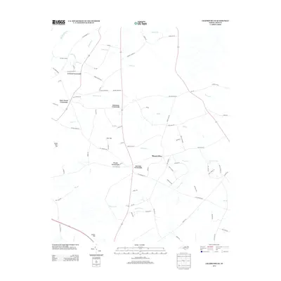
2013 Map of Chadbourn NE
USGS Topo · Published 2013About this map
Mount Olive and several historical intersection communities anchor this rural landscape in Columbus County. The map details a series of crossroads including Lennons Crossroads, Piney Forest Crossroads, Hickmans Crossroads, and Oak Dale Crossroads, reflecting a settlement pattern built around small-scale agricultural hubs and secondary transport routes. Named family roads such as Paul Willoughby Rd, Walter Raleigh Cir, and Monroe Kennedy Rd further highlight the genealogical depth of this coastal plain area. The geography is characterized by distinct pocosin or wetland features known as bays, specifically Brier Bay, Rough Horn Bay, and Button Bay. These low-lying areas are drained by an intricate network of watercourses like Slender Br, Big Br, and the Big Swamp Canal, while Horsepen Landing on the edge of a branch suggests historical water access points in an otherwise wooded interior.
Find a feature on this map
74 named features on this map. Tap any name to fly to it.
Don’t see what you’re looking for? This feature index may not catch every label — zoom into the map to look around manually.
Map Details
Editions of this 2013 Chadbourn NE Map
This is the sole edition of this map. No revisions or reprints were ever made.
Other maps of this area

1953 · Chadbourn
USGS Topo · 1:62,500

1953 · Florence
USGS Topo · 1:250,000

1954 · Florence
USGS Topo · 1:250,000

1955 · Whiteville
USGS Topo · 1:62,500

1955 · Elizabethtown
USGS Topo · 1:62,500

1957 · Bladenboro
USGS Topo · 1:62,500

1982 · Elizabethtown
USGS Topo · 1:100,000

1986 · Whiteville
USGS Topo · 1:100,000
1986 · Chadbourn
USGS Topo · 1:24,000
1986 · Evergreen
USGS Topo · 1:24,000
Featured Places
- Mount Olive, NC
- Wyatts Crossroads, NC
- Piney Forest Crossroads, NC
- Lennons Crossroads, NC
- Hickmans Crossroads, NC