
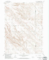
1966 Map of Chadron 3 SE
USGS Topo · Published 1967About this map
Antelope and the high plains of the Dawes and Sheridan County line define this portion of the Nebraska panhandle as it was surveyed in the mid-1960s. The landscape is marked by the deep incision of Sand Canyon and the transition into West Mirage and Hay Springs, reflecting a region of sparse settlement centered on rural education and local cemeteries. Genealogists may find particular value in the locations of the Antelope Valley Cem, which serves as a landmark in the northern reaches, and rural institutions like New Home Sch and Chimney Butte Sch. The presence of a Gravel Pit and the rugged terrain of the Craig area illustrate the practical land use and topographical challenges facing residents in this corner of the state during the Missouri River Basin development era.
Find a feature on this map
10 named features on this map. Tap any name to fly to it.
Don’t see what you’re looking for? This feature index may not catch every label — zoom into the map to look around manually.
Map Details
Editions of this 1966 Chadron 3 SE Map
2 editions found
Other maps of this area

1947 · Box Butte NE
USGS Topo · 1:24,000

1947 · Box Butte NW
USGS Topo · 1:24,000

1949 · Box Butte NE
USGS Topo · 1:24,000

1949 · Box Butte NW
USGS Topo · 1:24,000

1950 · Skunk Lake
USGS Topo · 1:62,500

1955 · Alliance
USGS Topo · 1:250,000

1957 · Alliance
USGS Topo · 1:250,000

1958 · Alliance
USGS Topo · 1:250,000

1960 · Hay Springs SW
USGS Topo · 1:24,000

1966 · Hay Springs
USGS Topo · 1:24,000