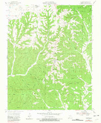
1955 Map of Chadwick
USGS Topo · Published 1981About this map
Chadwick and Oldfield anchor this mid-century portrait of the Ozark plateau, where the landscape is defined by the extensive reaches of the Mark Twain National Forest. The map reveals a deeply dissected terrain of narrow ridges and steep hollows, such as Strawberry Ridge and Cobb Ridge, which dictated the sparse settlement patterns of the era. The primary corridor follows the path of State Route 125, connecting the small communities and rural landmarks that sustained local life.
Find a feature on this map
46 named features on this map. Tap any name to fly to it.
Don’t see what you’re looking for? This feature index may not catch every label — zoom into the map to look around manually.
Map Details
Editions of this 1955 Chadwick Map
2 editions found
Other maps of this area

1884 · Springfield
USGS Topo · 1:125,000

1886 · Springfield
USGS Topo · 1:125,000

1907 · Forsyth
USGS Topo · 1:125,000

1937 · Bradleyville
USGS Topo · 1:48,000

1937 · Ozark
USGS Topo · 1:48,000

1939 · Fordland
USGS Topo · 1:62,500

1942 · Fordland
USGS Topo · 1:62,500

1943 · Ozark
USGS Topo · 1:62,500

1943 · Bradleyville
USGS Topo · 1:62,500

1945 · Harrison
USGS Topo · 1:250,000