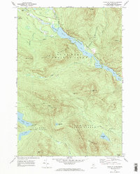
1969 Map of Chain Of Ponds
USGS Topo · Published 1973About this map
Natanis Pond, Long Pond, Bag Pond, and Lower Pond form a narrow aquatic chain through the high terrain of northern Franklin County. This landscape, surveyed in the late 1960s, is defined by the steep relief of the Indian Stream Chain of Ponds and Snow Mtn, where a Lookout Tower stands as a focal point for forest observation. The area is characterized by scattered outposts of human activity including Chain of Ponds Camp and Upper Farm, connected by primitive routes like the Arnold Pond Trail and Morrell Trail. Several Gravel Pits indicate local industry, while the drainage patterns of Horseshoe Stream and North Branch Alder Stream illustrate the complex hydrology of these highland townships. The map records the precise township boundaries, such as T 2 R 6 W B K P, which remain critical for historical land research in the Maine woods.
Find a feature on this map
40 named features on this map. Tap any name to fly to it.
Don’t see what you’re looking for? This feature index may not catch every label — zoom into the map to look around manually.
Map Details
Editions of this 1969 Chain Of Ponds Map
2 editions found
Other maps of this area

1928 · Chain Lakes
USGS Topo · 1:48,000

1931 · Cupsuptic
USGS Topo · 1:48,000

1932 · Kennebago Lake
USGS Topo · 1:48,000

1932 · Arnold Pond
USGS Topo · 1:48,000

1932 · Chain Lakes
USGS Topo · 1:62,500

1934 · Cupsuptic
USGS Topo · 1:62,500

1935 · Kennebago Lake
USGS Topo · 1:62,500

1935 · Chain Lakes
USGS Topo · 1:62,500

1935 · Cupsuptic
USGS Topo · 1:62,500

1935 · Arnold Pond
USGS Topo · 1:62,500
Featured Places
- Kibby Township, ME
- Alder Stream Township, ME
- Round Mountain, Alder Stream Township
- Seven Ponds Township, ME
- Chain of Ponds Township, ME