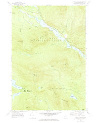
1969 Map of Chain Of Ponds
USGS Topo · Published 1973About this map
Indian Stream Chain of Ponds anchors this remote section of Franklin County, where a string of narrow water bodies including Natanis Pond, Long Pond, and Lower Pond wind through the township boundaries of T 2 R 6 and T 3 R 5. The landscape is defined by the historic Arnold Trail, which follows the northern banks and marshes of Caribou Bog and the Horseshoe Pond outlet. This route preserves the traditional path used by travelers and hunters through the dense woods toward the Canadian border.
Find a feature on this map
38 named features on this map. Tap any name to fly to it.
Don’t see what you’re looking for? This feature index may not catch every label — zoom into the map to look around manually.
Map Details
Editions of this 1969 Chain Of Ponds Map
2 editions found
Other maps of this area

1928 · Chain Lakes
USGS Topo · 1:48,000

1931 · Cupsuptic
USGS Topo · 1:48,000

1932 · Kennebago Lake
USGS Topo · 1:48,000

1932 · Arnold Pond
USGS Topo · 1:48,000

1932 · Chain Lakes
USGS Topo · 1:62,500

1934 · Cupsuptic
USGS Topo · 1:62,500

1935 · Kennebago Lake
USGS Topo · 1:62,500

1935 · Chain Lakes
USGS Topo · 1:62,500

1935 · Cupsuptic
USGS Topo · 1:62,500

1935 · Arnold Pond
USGS Topo · 1:62,500
Featured Places
- Kibby Township, ME
- Alder Stream Township, ME
- Round Mountain, Alder Stream Township
- Seven Ponds Township, ME
- Chain of Ponds Township, ME