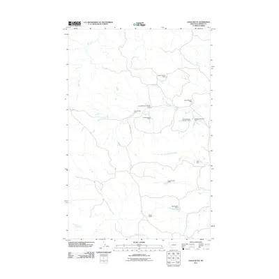
2011 Map of Chalk Butte
USGS Topo · Published 2011About this map
Chalk Butte rises as a prominent landmark in this cattle-ranching landscape of Garfield County, Montana, at the start of the 2010s. The region is defined by a dense network of water management infrastructure, where local drainages like Snow Creek and the South Fork Snow Creek are harnessed by numerous small-scale reservoirs. Many of these features, such as the Frank McKeever Number 1 Dam and Hauso Reservoir Dam, bear the names of local families, reflecting a history of private land management and water rights in this arid plains environment. The terrain is further etched by the winding courses of Billy Creek and Smoky Butte Creek, while the presence of W Snow Creek Rd provides a singular corridor through the drainage basins. This survey serves as a clear record of how rural infrastructure and land use patterns follow the natural flow of the watershed.
Find a feature on this map
17 named features on this map. Tap any name to fly to it.
Don’t see what you’re looking for? This feature index may not catch every label — zoom into the map to look around manually.
Map Details
Editions of this 2011 Chalk Butte Map
This is the sole edition of this map. No revisions or reprints were ever made.
Other maps of this area

1954 · Jordan
USGS Topo · 1:250,000

1956 · Jordan
USGS Topo · 1:250,000

1958 · Jordan
USGS Topo · 1:250,000

1964 · Jordan
USGS Topo · 1:250,000

1971 · Hell Hollow
USGS Topo · 1:24,000

1971 · Wolfe Coulee
USGS Topo · 1:24,000

1971 · Wagon Coulee
USGS Topo · 1:24,000

1971 · Sawmill Creek
USGS Topo · 1:24,000

1971 · Chalk Butte
USGS Topo · 1:24,000
1971 · Swede Ridge
USGS Topo · 1:24,000