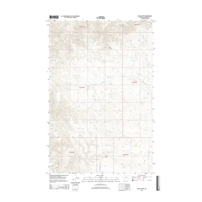
2014 Map of Chalk Butte
USGS Topo · Published 2014About this map
Chalk Butte rises as a prominent landmark in this eastern Montana landscape, anchoring a region defined by an intricate network of drainage coulees and seasonal creeks. The terrain is shaped by the headwaters and winding paths of Billy Coulee, Snow Cr, and the S Fork Snow Cr. This 2014 survey captures the character of the Garfield County backcountry, where large-scale land divisions such as t21n r34e and t22n r35e organize the open range. Transportation is limited to sparse secondary routes including Snow Creek Rd and Four Corners Ln, illustrating the isolation of this ranching and grazing country. Further south, the map details the reaches of Seven Blackfoot Cr and Smoky Butte Cr, providing a precise look at the hydrology that dictates life and land use in this arid portion of the Missouri River watershed.
Find a feature on this map
15 named features on this map. Tap any name to fly to it.
Don’t see what you’re looking for? This feature index may not catch every label — zoom into the map to look around manually.
Map Details
Editions of this 2014 Chalk Butte Map
This is the sole edition of this map. No revisions or reprints were ever made.
Other maps of this area

1954 · Jordan
USGS Topo · 1:250,000

1956 · Jordan
USGS Topo · 1:250,000

1958 · Jordan
USGS Topo · 1:250,000

1964 · Jordan
USGS Topo · 1:250,000

1971 · Hell Hollow
USGS Topo · 1:24,000

1971 · Wolfe Coulee
USGS Topo · 1:24,000

1971 · Wagon Coulee
USGS Topo · 1:24,000

1971 · Sawmill Creek
USGS Topo · 1:24,000

1971 · Chalk Butte
USGS Topo · 1:24,000
1971 · Swede Ridge
USGS Topo · 1:24,000