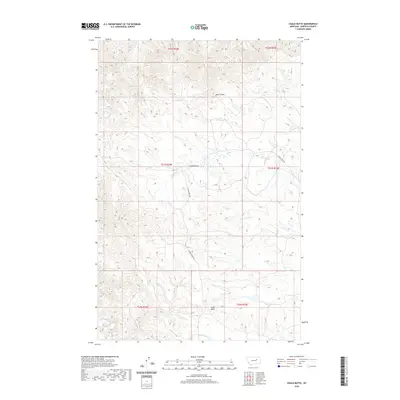
2020 Map of Chalk Butte
USGS Topo · Published 2020About this map
Chalk Butte stands as a prominent landmark in this segment of Garfield County, overlooking a landscape defined by an intricate network of drainage systems. The hydrography of the region is characterized by seasonal watercourses and coulees, including the winding Billy Coulee and the headwaters of Seven Blackfoot Cr. The map illustrates the sparsely populated ranching country of eastern Montana, where human presence is primarily marked by a handful of established routes such as E Snow Creek Rd and W Snow Creek Rd. These roads provide the vital links across the township and range lines of t21n r34e and t21n r35e, connecting remote homesteads and grazing lands. The convergence of Snow Cr and S Fork Snow Cr further highlights the complex erosion patterns that have shaped this high plains environment.
Find a feature on this map
16 named features on this map. Tap any name to fly to it.
Don’t see what you’re looking for? This feature index may not catch every label — zoom into the map to look around manually.
Map Details
Editions of this 2020 Chalk Butte Map
This is the sole edition of this map. No revisions or reprints were ever made.
Other maps of this area

1954 · Jordan
USGS Topo · 1:250,000

1956 · Jordan
USGS Topo · 1:250,000

1958 · Jordan
USGS Topo · 1:250,000

1964 · Jordan
USGS Topo · 1:250,000

1971 · Hell Hollow
USGS Topo · 1:24,000

1971 · Wolfe Coulee
USGS Topo · 1:24,000

1971 · Wagon Coulee
USGS Topo · 1:24,000

1971 · Sawmill Creek
USGS Topo · 1:24,000

1971 · Chalk Butte
USGS Topo · 1:24,000
1971 · Swede Ridge
USGS Topo · 1:24,000