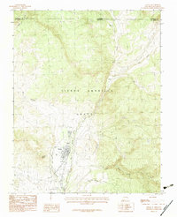
1983 Map of Chama
USGS Topo · Published 1983About this map
Chama sits at the confluence of several significant watercourses in northern Rio Arriba County, where the Rio Chama and Rio Chamita converge. This 1983 provisional survey highlights the high-elevation terrain of the Tierra Amarilla Grant, a massive land grant area characterized by steep canyons and drainage networks like Little Willow Creek and Wolf Creek. The settlement pattern follows the valley floor, with the small community of Lobato positioned north of the primary town center. The landscape is dominated by the high relief of Rabbit Peak and the surrounding mountains, which separate the various creek forks. Industrial activity is minimally represented on this sheet, though a Gravel Pit near the river indicates local resource extraction. The map also delineates the state boundary where New Mexico meets Colorado, following the northern extent of Nabor Creek.
Find a feature on this map
15 named features on this map. Tap any name to fly to it.
Don’t see what you’re looking for? This feature index may not catch every label — zoom into the map to look around manually.
Map Details
Editions of this 1983 Chama Map
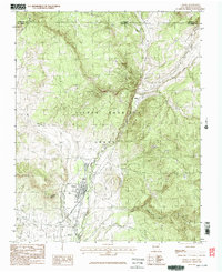
2 editions found
Other maps of this area

1913 · Summitville
USGS Topo · 1:125,000

1915 · Summitville
USGS Topo · 1:125,000

1918 · Tusas
USGS Topo · 1:125,000

1922 · Conejos
USGS Topo · 1:125,000

1945 · Durango
USGS Topo · 1:250,000

1953 · Durango
USGS Topo · 1:250,000

1954 · Durango
USGS Topo · 1:250,000

1954 · Aztec
USGS Topo · 1:250,000

1955 · Chama
USGS Topo · 1:62,500

1955 · Brazos Peak
USGS Topo · 1:62,500