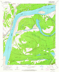
1963 Map of Chamblee
USGS Topo · Published 1964About this map
Buena Vista Island and Rodney Island dominate this reach of the Mississippi River in the early 1960s, showing a landscape defined by shifting watercourses and alluvial deposits. The Rodney Cutoff illustrates the river's dynamic engineering, while numerous chutes and bayous like Gilliam Chute and Choctaw Bayou isolate landmasses between the main channel and the backwater lakes. Evidence of land use is visible in the Locust Ridge Oil Field and the Durango Plantation near Coles Creek Pumping Station Slough. Settlement patterns follow the higher ground and historical transportation corridors, such as the Missouri Pacific line serving Chamblee and the Old Railroad Grade near Waterproof. For those researching local history, the location of the Myrtle Grove Cem and various family-named features like Kings Point and Ashland provide specific points of interest on the Louisiana-Mississippi border.
Find a feature on this map
47 named features on this map. Tap any name to fly to it.
Don’t see what you’re looking for? This feature index may not catch every label — zoom into the map to look around manually.
Map Details
Editions of this 1963 Chamblee Map
2 editions found
Other maps of this area

1909 · Delta Bridge
USGS Topo · 1:24,000

1909 · Lake Bruen
USGS Topo · 1:24,000

1921 · Natchez
USGS Topo · 1:48,000

1922 · Natchez
USGS Topo · 1:62,500

1939 · Lorman
USGS Topo · 1:62,500

1939 · Natchez
USGS Topo · 1:62,500

1939 · Locust Ridge
USGS Topo · 1:62,500

1953 · Natchez
USGS Topo · 1:250,000

1956 · Natchez
USGS Topo · 1:250,000

1958 · St. Joseph
USGS Topo · 1:62,500