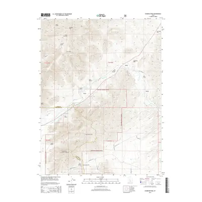
2014 Map of Champlin Peak
USGS Topo · Published 2014About this map
Champlin Peak stands as the high point in a landscape defined by the convergence of the Gilson Mountains and the Canyon Mountains along the border of Juab and Millard counties. This 2014 survey documents a critical junction of water management and topography, where the Sevier River winds through Leamington Canyon and Sevier Canyon. The agricultural infrastructure of the region is evident in the presence of the Central Utah Canal, Leamington Canal, and Macks Ditch, which redirect water through the valley floor near the small settlements of Soma and Uisco. Much of the southern terrain is protected within the Fishlake National Forest, where steep drainages like Tank Canyon and Wood Canyon carve into the mountain faces. Local transit is marked by several named routes such as Leamington Pass Rd and JPP Tower Rd, facilitating movement through the high Leamington Pass.
Find a feature on this map
33 named features on this map. Tap any name to fly to it.
Don’t see what you’re looking for? This feature index may not catch every label — zoom into the map to look around manually.
Map Details
Editions of this 2014 Champlin Peak Map
This is the sole edition of this map. No revisions or reprints were ever made.
Other maps of this area

1885 · Sevier Desert
USGS Topo · 1:250,000

1951 · Oak City
USGS Topo · 1:62,500

1952 · Scipio North
USGS Topo · 1:62,500

1953 · Delta
USGS Topo · 1:250,000

1958 · Delta
USGS Topo · 1:250,000

1962 · Delta
USGS Topo · 1:250,000

1962 · Lynndyl
USGS Topo · 1:62,500

1967 · Champlin Peak
USGS Topo · 1:24,000
1967 · Furner Ridge
USGS Topo · 1:24,000
1967 · Sage Valley
USGS Topo · 1:24,000