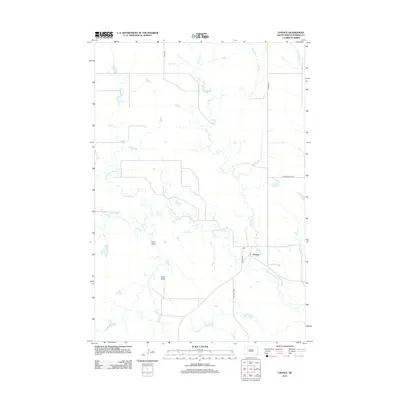
2012 Map of Chance
USGS Topo · Published 2012About this map
Chance serves as the focal point of this Perkins County landscape, situated where Chance Rd meets the winding course of Hart Cr. This prairie terrain is defined by its drainage network, particularly the prominent Thunder Butte Cr which meanders across the central portion of the sheet. The local geography is marked by distinctive landforms such as Tailor Butte and the adjacent Tailor Draw, reflecting the naming traditions of early ranching families in the region.
Find a feature on this map
11 named features on this map. Tap any name to fly to it.
Don’t see what you’re looking for? This feature index may not catch every label — zoom into the map to look around manually.
Map Details
Editions of this 2012 Chance Map
This is the sole edition of this map. No revisions or reprints were ever made.
Other maps of this area

1954 · Lemmon
USGS Topo · 1:250,000

1957 · Lemmon
USGS Topo · 1:250,000

1983 · Boxcar Buttes
USGS Topo · 1:24,000

1983 · Bison
USGS Topo · 1:24,000

1983 · Sunrise Butte
USGS Topo · 1:24,000

1983 · Meadow
USGS Topo · 1:24,000

1983 · Coal Springs SW
USGS Topo · 1:24,000

1983 · Owen Lake
USGS Topo · 1:24,000

1983 · Coal Springs NW
USGS Topo · 1:24,000
1983 · Chance
USGS Topo · 1:24,000