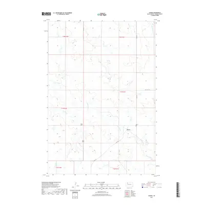
2017 Map of Chance
USGS Topo · Published 2017About this map
Chance serves as the focal point for this Perkins County landscape, where the prairie topography is defined by the winding paths of several intermittent waterways. The area is dominated by the drainage systems of Thunder Butte Cr and Hart Cr, which carve through the land alongside Big Meadow Cr and Cone Tree Cr. Evidence of the region’s ranching and homesteading history is visible in the placement of the Chance Cem and the naming of local landmarks like Tailor Butte and Tailor Draw. This survey illustrates a quiet rural network connected by Chance Rd and Rolling Hills Rd, reflecting the enduring structure of western South Dakota's township and range system at the start of the 21st century.
Find a feature on this map
18 named features on this map. Tap any name to fly to it.
Don’t see what you’re looking for? This feature index may not catch every label — zoom into the map to look around manually.
Map Details
Editions of this 2017 Chance Map
This is the sole edition of this map. No revisions or reprints were ever made.
Other maps of this area

1954 · Lemmon
USGS Topo · 1:250,000

1957 · Lemmon
USGS Topo · 1:250,000

1983 · Boxcar Buttes
USGS Topo · 1:24,000

1983 · Bison
USGS Topo · 1:24,000

1983 · Sunrise Butte
USGS Topo · 1:24,000

1983 · Meadow
USGS Topo · 1:24,000

1983 · Coal Springs SW
USGS Topo · 1:24,000

1983 · Owen Lake
USGS Topo · 1:24,000

1983 · Coal Springs NW
USGS Topo · 1:24,000
1983 · Chance
USGS Topo · 1:24,000