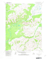
1970 Map of Chandalar A-6
USGS Topo · Published 1983About this map
The South Fork Koyukuk River winds through this 1970 Alaskan interior survey, defining a landscape of isolated seasonal outposts and aviation-dependent access. In the northern reaches, the Myrtle Creek Landing Strip and a nearby Winter Trail represent the primary logistical arteries for the region, connecting unnamed Cabins to the wider territory. The terrain is marked by distinctive geological features such as the Eagle Cliff and the expansive South Fork Flats, where the river network becomes particularly complex.
Find a feature on this map
15 named features on this map. Tap any name to fly to it.
Don’t see what you’re looking for? This feature index may not catch every label — zoom into the map to look around manually.
Map Details
Editions of this 1970 Chandalar A-6 Map
2 editions found
Other maps of this area

1951 · Bettles
USGS Topo · 1:250,000

1951 · Chandalar
USGS Topo · 1:250,000

1951 · Beaver
USGS Topo · 1:250,000

1951 · Wiseman
USGS Topo · 1:250,000

1956 · Chandalar
USGS Topo · 1:250,000

1956 · Bettles
USGS Topo · 1:250,000

1956 · Wiseman
USGS Topo · 1:250,000

1956 · Beaver
USGS Topo · 1:250,000

1964 · Wiseman
USGS Topo · 1:250,000

1964 · Chandalar
USGS Topo · 1:250,000