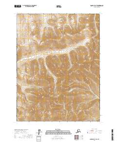
2017 Map of Chandalar B-1 SW
USGS Topo · Published 2017About this map
Thazzik Mtn dominates the southern landscape of this remote interior Alaska quadrangle, situated within the Yukon-Koyukuk Census Area. The topography is defined by significant elevation changes, with drainage basins formed by Funchion Cr carving through the northern and central sections, while Zimmerman Cr flows southward from the mountain slopes. To the northeast, the headwaters of Flat Cr indicate the start of another drainage system. This 2017 survey reflects the largely undeveloped character of the Brooks Range foothills, where the absence of roads and human settlements highlights a wilderness area defined almost entirely by its high-altitude terrain and cold-water creek networks. The map provides a detailed record of the township and range boundaries, including t29n r1e and t28n r2e, which are essential for locating specific wilderness tracts.
Find a feature on this map
8 named features on this map. Tap any name to fly to it.
Don’t see what you’re looking for? This feature index may not catch every label — zoom into the map to look around manually.
Map Details
Editions of this 2017 Chandalar B-1 SW Map
This is the sole edition of this map. No revisions or reprints were ever made.
Other maps of this area

1951 · Chandalar
USGS Topo · 1:250,000

1956 · Chandalar
USGS Topo · 1:250,000

1964 · Chandalar
USGS Topo · 1:250,000
1990 · Chandalar A-2
USGS Topo · 1:63,360
1990 · Chandalar A-1
USGS Topo · 1:63,360
1990 · Chandalar B-1
USGS Topo · 1:63,360
1990 · Chandalar B-2
USGS Topo · 1:63,360
2017 · Chandalar B-2 NE
USGS Topo · 1:25,000
2017 · Chandalar A-1 NW
USGS Topo · 1:25,000
2017 · Chandalar A-1 NE
USGS Topo · 1:25,000