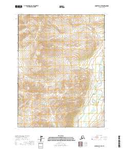
2017 Map of Chandalar B-4 NW
USGS Topo · Published 2017About this map
The North Fork Chandalar River winds through this high-latitude terrain, defining the eastern edge of a landscape where water systems dictate the topography. In the west, the S Fork Koyukuk River and the high point at Woodland Echo Pass mark a significant divide between drainage basins. This interior Alaskan survey reveals a network of small tributaries such as Schrader Cr and Ruby Cr that cut through the elevation. The dominance of the Woodland Echo Cr system in the central portion of the map illustrates the complex hydrology that characterizes the region. Without roads or permanent settlements, the map focuses on these named natural features that serve as the primary landmarks for navigation in the Yukon-Koyukuk area.
Find a feature on this map
13 named features on this map. Tap any name to fly to it.
Don’t see what you’re looking for? This feature index may not catch every label — zoom into the map to look around manually.
Map Details
Editions of this 2017 Chandalar B-4 NW Map
This is the sole edition of this map. No revisions or reprints were ever made.
Other maps of this area

1951 · Chandalar
USGS Topo · 1:250,000

1956 · Chandalar
USGS Topo · 1:250,000

1964 · Chandalar
USGS Topo · 1:250,000

1971 · Chandalar B-5
USGS Topo · 1:63,360

1971 · Chandalar C-5
USGS Topo · 1:63,360
1971 · Chandalar C-4
USGS Topo · 1:63,360
1971 · Chandalar B-4
USGS Topo · 1:63,360
2017 · Chandalar C-4 SE
USGS Topo · 1:25,000
2017 · Chandalar B-4 SW
USGS Topo · 1:25,000
2017 · Chandalar B-4 NE
USGS Topo · 1:25,000