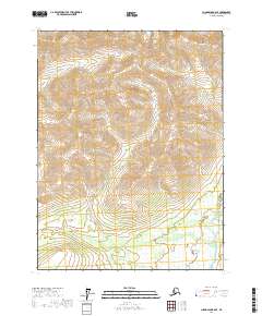
2017 Map of Chandalar B-6 SE
USGS Topo · Published 2017About this map
Marion Cr and Boulder Cr descend from the high, ridged terrain of the north into the expansive South Fork Flats below. This 2017 survey captures the intersection of several township boundaries, including t29n r10w, as the landscape transitions from steep contour intervals to the wetland-rich bottomlands of the South Fork Koyukuk River valley. The drainage patterns of Portland Cr and its tributaries illustrate the natural flow of the Yukon-Koyukuk region before reaching the main river channel in the southeast. Without roads or permanent settlements, the map focuses on the raw topography and hydraulic network of this interior Alaskan wilderness.
Find a feature on this map
9 named features on this map. Tap any name to fly to it.
Don’t see what you’re looking for? This feature index may not catch every label — zoom into the map to look around manually.
Map Details
Editions of this 2017 Chandalar B-6 SE Map
This is the sole edition of this map. No revisions or reprints were ever made.
Other maps of this area

1951 · Chandalar
USGS Topo · 1:250,000

1956 · Chandalar
USGS Topo · 1:250,000

1964 · Chandalar
USGS Topo · 1:250,000
1970 · Chandalar A-6
USGS Topo · 1:63,360
1970 · Chandalar A-5
USGS Topo · 1:63,360

1971 · Chandalar B-5
USGS Topo · 1:63,360
1971 · Chandalar B-6
USGS Topo · 1:63,360
2017 · Chandalar B-5 SW
USGS Topo · 1:25,000
2017 · Chandalar A-6 NW
USGS Topo · 1:25,000
2017 · Chandalar B-6 SW
USGS Topo · 1:25,000