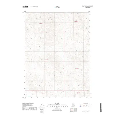
2017 Map of Chandalar C-3 NE
USGS Topo · Published 2017About this map
Squaw Lake lies at the southwestern edge of this interior landscape, marking a rare break in the high-elevation terrain of the Yukon-Koyukuk region. This 2017 topographic study highlights the complex drainage patterns of the area, defined by the headwaters and runs of several small creeks including Our Cr in the north and Sammy Cr in the south. The map provides a detailed view of the township and range divisions, showing the boundaries between t34n r3w, t33n r3w, and their eastern counterparts. The lack of infrastructure or named settlements underscores the wilderness character of this part of the Unorganized Borough, where natural water features like Bridge Cr are the primary landmarks used for navigation and land management.
Find a feature on this map
10 named features on this map. Tap any name to fly to it.
Don’t see what you’re looking for? This feature index may not catch every label — zoom into the map to look around manually.
Map Details
Editions of this 2017 Chandalar C-3 NE Map
This is the sole edition of this map. No revisions or reprints were ever made.
Other maps of this area

1951 · Chandalar
USGS Topo · 1:250,000

1956 · Chandalar
USGS Topo · 1:250,000

1964 · Chandalar
USGS Topo · 1:250,000

1990 · Chandalar C-2
USGS Topo · 1:63,360
1990 · Chandalar D-2
USGS Topo · 1:63,360
1990 · Chandalar C-3
USGS Topo · 1:63,360
1990 · Chandalar D-3
USGS Topo · 1:63,360
2017 · Chandalar C-2 NW
USGS Topo · 1:25,000
2017 · Chandalar D-2 SW
USGS Topo · 1:25,000
2017 · Chandalar C-2 SW
USGS Topo · 1:25,000