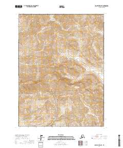
2017 Map of Chandalar D-6 SE
USGS Topo · Published 2017About this map
Snowden Mtn dominates the central landscape of this wilderness area in the Yukon-Koyukuk region, its elevation contours defining the local watershed. The drainage systems of Snowden Cr and Nutirwik Cr flow through the high-altitude terrain, eventually feeding into the Mathews River. Surveyed in the early 21st century, the map illustrates the precise township and range boundaries including t35n r10w and t34n r9w. This remote landscape is free of any named roads or settlements, reflecting its character as a protected or largely inaccessible reach of the Alaskan interior. The mapping detail focuses on the sharp elevation changes and the complex network of mountain streams that characterize the eastern Brooks Range foothills.
Find a feature on this map
8 named features on this map. Tap any name to fly to it.
Don’t see what you’re looking for? This feature index may not catch every label — zoom into the map to look around manually.
Map Details
Editions of this 2017 Chandalar D-6 SE Map
This is the sole edition of this map. No revisions or reprints were ever made.
Other maps of this area

1951 · Chandalar
USGS Topo · 1:250,000

1956 · Chandalar
USGS Topo · 1:250,000

1964 · Chandalar
USGS Topo · 1:250,000
1971 · Chandalar D-6
USGS Topo · 1:63,360
1971 · Chandalar D-5
USGS Topo · 1:63,360

1971 · Chandalar C-5
USGS Topo · 1:63,360
1971 · Chandalar C-6
USGS Topo · 1:63,360
2017 · Chandalar D-5 SW
USGS Topo · 1:25,000
2017 · Chandalar C-6 NW
USGS Topo · 1:25,000
2017 · Chandalar D-5 NW
USGS Topo · 1:25,000