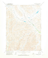
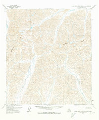
1971 Map of Chandalar D-5
USGS Topo · Published 1973About this map
North Fork Chandalar River winds through this northern interior landscape, representing a remote corridor in the Brooks Range foothills during the early 1970s. The region is defined by its complex drainage network, where the river meets significant tributaries such as Quartz Creek and Robert Creek. To the southwest, the Mathews River carves through the terrain, while Big Spruce Creek flows further south. This 1971 survey serves as a fundamental record of the wilderness before significant modern infrastructure, captured just as the North Boundary Fairbanks Meridian was being formally documented through photogrammetric methods. The map illustrates a landscape devoid of established roads or trails, emphasizing the primary role of these watercourses for navigation and geography in this part of Alaska.
Find a feature on this map
6 named features on this map. Tap any name to fly to it.
Don’t see what you’re looking for? This feature index may not catch every label — zoom into the map to look around manually.
Map Details
Editions of this 1971 Chandalar D-5 Map
2 editions found
Other maps of this area

1951 · Chandalar
USGS Topo · 1:250,000

1951 · Brooks
USGS Topo · 1:250,000

1956 · Chandalar
USGS Topo · 1:250,000

1956 · Philip Smith Mountains
USGS Topo · 1:250,000

1964 · Chandalar
USGS Topo · 1:250,000

1964 · Philip Smith Mountains
USGS Topo · 1:250,000
1971 · Philip Smith Mountains A-5
USGS Topo · 1:63,360
1971 · Chandalar D-6
USGS Topo · 1:63,360
1971 · Philip Smith Mountains A-4
USGS Topo · 1:63,360

1971 · Chandalar C-5
USGS Topo · 1:63,360