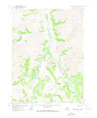
1971 Map of Chandalar C-6
USGS Topo · Published 1973About this map
Sukakpak Mountain dominates the central landscape of this Brooks Range interior, where the Middle Fork Koyukuk River and Dietrich River converge. The 1971 annotation of this area captures a remote northern territory defined by seasonal transit and resource exploration, evidenced by the Winter Road and Winter Trail cutting through the valleys. The presence of Dietrich Camp and its associated Landing Strip suggests the logistical footprint required for operations in this high-latitude environment before permanent modern infrastructure was fully established.
Find a feature on this map
30 named features on this map. Tap any name to fly to it.
Don’t see what you’re looking for? This feature index may not catch every label — zoom into the map to look around manually.
Map Details
Editions of this 1971 Chandalar C-6 Map
2 editions found
Other maps of this area

1951 · Chandalar
USGS Topo · 1:250,000

1951 · Wiseman
USGS Topo · 1:250,000

1956 · Chandalar
USGS Topo · 1:250,000

1956 · Wiseman
USGS Topo · 1:250,000

1964 · Wiseman
USGS Topo · 1:250,000

1964 · Chandalar
USGS Topo · 1:250,000
1971 · Chandalar D-6
USGS Topo · 1:63,360
1971 · Chandalar D-5
USGS Topo · 1:63,360

1971 · Chandalar B-5
USGS Topo · 1:63,360

1971 · Chandalar C-5
USGS Topo · 1:63,360