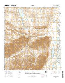
2016 Map of Chandler Lake B-3 SW
USGS Topo · Published 2016About this map
Gates Of The Arctic National Park encompasses the southern portion of this interior Alaska survey, where the Brooks Range landscape transitions into high-altitude drainage systems. The northern reaches are dominated by Natvakruak Lake and the smaller Makatuk Lake, which serve as critical water sources in an otherwise high-relief environment. Steep elevations are anchored by Nasaurak Mtn, overlooking a network of seasonal watercourses like Akmagolik Cr and Natvakruak Cr. The presence of the Anaktuvuk River on the eastern edge of the quadrangle suggests the natural corridor used for millennia by indigenous travelers and wildlife. This 2016 data represents a contemporary look at a wilderness area that remains largely unchanged by permanent human infrastructure, highlighting the preservation of Arctic watershed patterns.
Find a feature on this map
16 named features on this map. Tap any name to fly to it.
Don’t see what you’re looking for? This feature index may not catch every label — zoom into the map to look around manually.
Map Details
Editions of this 2016 Chandler Lake B-3 SW Map
This is the sole edition of this map. No revisions or reprints were ever made.
Other maps of this area

1951 · Chandler Lake
USGS Topo · 1:250,000

1956 · Chandler Lake
USGS Topo · 1:250,000

1964 · Chandler Lake
USGS Topo · 1:250,000

1971 · Chandler Lake A-3
USGS Topo · 1:63,360
1986 · Chandler Lake A-4
USGS Topo · 1:63,360
1987 · Chandler Lake B-3
USGS Topo · 1:63,360
1987 · Chandler Lake B-4
USGS Topo · 1:63,360
2016 · Chandler Lake B-4 NE
USGS Topo · 1:25,000
2016 · Chandler Lake B-4 SE
USGS Topo · 1:25,000
2016 · Chandler Lake A-3 NE
USGS Topo · 1:25,000