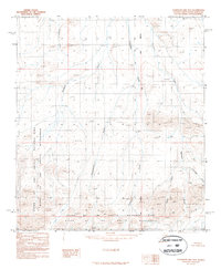
1987 Map of Chandler Lake B-4
USGS Topo · Published 1987About this map
Gates of the Arctic National Park Wilderness covers a significant portion of this high-latitude terrain, as defined by the Alaska National Interest Lands Conservation Act of 1980. The landscape is dominated by a complex network of north-flowing watercourses, including the Siksikpuk River and its various tributaries such as Autumn Creek and Encampment Creek. The map provides a detailed view of the drainage patterns through the Brooks Range foothills, where the Umiat Meridian serves as a primary surveying reference point. Topographic features are captured through aerial photography taken in 1982, showing the winding paths of Tiglukpuk Creek and Confusion Creek as they move through the federally protected wilderness area. This provisional survey highlights the remote character of the North Slope, where no roads or trails are noted, leaving the land's character entirely to its natural ridges and the basins of Skimo Creek and Firestone Creek.
Find a feature on this map
9 named features on this map. Tap any name to fly to it.
Don’t see what you’re looking for? This feature index may not catch every label — zoom into the map to look around manually.
Map Details
Editions of this 1987 Chandler Lake B-4 Map
This is the sole edition of this map. No revisions or reprints were ever made.
Other maps of this area

1951 · Chandler Lake
USGS Topo · 1:250,000

1956 · Chandler Lake
USGS Topo · 1:250,000

1964 · Chandler Lake
USGS Topo · 1:250,000

1971 · Chandler Lake A-3
USGS Topo · 1:63,360
1986 · Chandler Lake A-5
USGS Topo · 1:63,360
1986 · Chandler Lake A-4
USGS Topo · 1:63,360
1987 · Chandler Lake B-5
USGS Topo · 1:63,360
1987 · Chandler Lake C-4
USGS Topo · 1:63,360
1987 · Chandler Lake C-5
USGS Topo · 1:63,360
1987 · Chandler Lake C-3
USGS Topo · 1:63,360