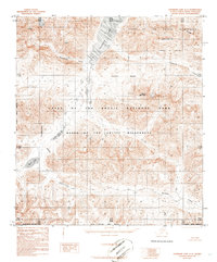
1986 Map of Chandler Lake A-5
USGS Topo · Published 1986About this map
The Continental Divide winds through this high-latitude terrain, marking a fundamental watershed boundary in the Brooks Range. This mid-1980s documentation by the U.S. Geological Survey captures a landscape largely protected within the Gates of the Arctic National Park and the associated Gates of the Arctic Wilderness. The topography is dominated by glacial features and alpine drainage systems, with Chandler Lake serving as a significant water body in the northern section. Peaks such as Mount Mac Vicar rise above the complex network of stream valleys, including Iklauyaurak Creek and Kollutarak Creek. The map provides a clear look at the South Boundary Umiat Meridian and the North Slope Borough line, illustrating the administrative divisions of this arctic wilderness before modern satellite mapping became the primary standard.
Find a feature on this map
15 named features on this map. Tap any name to fly to it.
Don’t see what you’re looking for? This feature index may not catch every label — zoom into the map to look around manually.
Map Details
Editions of this 1986 Chandler Lake A-5 Map
2 editions found
Other maps of this area

1951 · Survey Pass
USGS Topo · 1:250,000

1951 · Chandler Lake
USGS Topo · 1:250,000

1951 · Killik River
USGS Topo · 1:250,000

1951 · Wiseman
USGS Topo · 1:250,000

1956 · Wiseman
USGS Topo · 1:250,000

1956 · Survey Pass
USGS Topo · 1:250,000

1956 · Chandler Lake
USGS Topo · 1:250,000

1956 · Killik River
USGS Topo · 1:250,000

1964 · Survey Pass
USGS Topo · 1:250,000

1964 · Wiseman
USGS Topo · 1:250,000