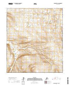
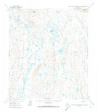
2017 Map of Chandler Lake C-1 NE
USGS Topo · Published 2017About this map
May Creek winds through this remote expanse of the North Slope, serving as the primary drainage for the undulating tundra and foothills documented in this 2017 survey. The landscape is defined by the Public Land Survey System boundaries of t8s r8e, t8s r9e, t9s r8e, and t9s r9e, which provide a legal framework for a wilderness largely devoid of permanent human infrastructure. The hydrography of May Creek and its unnamed tributaries reveals the intricate drainage patterns essential for understanding the seasonal shifts of this Arctic environment. Without roads or settlements, the map focuses on the raw topography and the subtle transitions of the terrain, offering a clear view of the land before any modern industrial footprint or development altered the watershed's natural course.
Find a feature on this map
5 named features on this map. Tap any name to fly to it.
Don’t see what you’re looking for? This feature index may not catch every label — zoom into the map to look around manually.
Map Details
Editions of this 2017 Chandler Lake C-1 NE Map
This is the sole edition of this map. No revisions or reprints were ever made.
Other maps of this area

1951 · Chandler Lake
USGS Topo · 1:250,000

1951 · Brooks
USGS Topo · 1:250,000

1956 · Philip Smith Mountains
USGS Topo · 1:250,000

1956 · Chandler Lake
USGS Topo · 1:250,000

1964 · Philip Smith Mountains
USGS Topo · 1:250,000

1964 · Chandler Lake
USGS Topo · 1:250,000
1971 · Chandler Lake D-1
USGS Topo · 1:63,360
1971 · Chandler Lake C-1
USGS Topo · 1:63,360
1971 · Philip Smith Mountains D-5
USGS Topo · 1:63,360
1971 · Philip Smith Mountains C-5
USGS Topo · 1:63,360