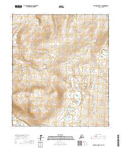
2017 Map of Chandler Lake D-1 NW
USGS Topo · Published 2017About this map
Nanushuk River provides the primary drainage for this high-latitude terrain within the North Slope Borough. This 2017 edition details a landscape primarily organized by the Public Land Survey System, showing the boundaries of several townships including t5s r6e, t5s r7e, t5s r8e, t6s r6e, t6s r7e, and t6s r8e. The topography is characterized by a series of north-south ridges and upland basins, with numerous small ponds and lakes distributed throughout the lower elevations. The map reveals the precise relief of this remote area, which remains largely devoid of modern roads or permanent settlements, reflecting the wilderness character of Alaska's northern reaches.
Find a feature on this map
7 named features on this map. Tap any name to fly to it.
Don’t see what you’re looking for? This feature index may not catch every label — zoom into the map to look around manually.
Map Details
Editions of this 2017 Chandler Lake D-1 NW Map
This is the sole edition of this map. No revisions or reprints were ever made.
Other maps of this area

1951 · Chandler Lake
USGS Topo · 1:250,000

1952 · Umiat
USGS Topo · 1:250,000

1956 · Chandler Lake
USGS Topo · 1:250,000

1956 · Umiat
USGS Topo · 1:250,000

1964 · Chandler Lake
USGS Topo · 1:250,000

1964 · Umiat
USGS Topo · 1:250,000
1971 · Chandler Lake D-1
USGS Topo · 1:63,360

1971 · Umiat A-2
USGS Topo · 1:63,360
1971 · Chandler Lake D-2
USGS Topo · 1:63,360
1971 · Umiat A-1
USGS Topo · 1:63,360