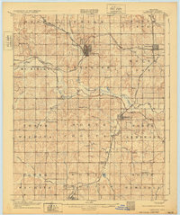
1907 Map of Chandler
USGS Topo · Published 1932About this map
Chandler serves as the central hub for this early Oklahoma Territory landscape, which was surveyed just as the regional rail network was becoming firmly established. The map reveals a complex web of transportation, where the St Louis and San Francisco RR and the Chicago Rock Island and Pacific RR converge near Bellcow. The settlement pattern follows the drainages of the Deep Fork Canadian River and its many tributaries like Pecan Creek and Quapaw Creek. Beyond the larger towns of Davenport and Sparks, the rural character is defined by a high density of country schools, including Sweet Home Sch, Kickapoo Valley Sch, and Red Eagle Sch. These small educational outposts, scattered across townships like North Choctaw and South Seminole, provide essential location data for researchers tracing family homesteads and local social history from the early twentieth century.
Find a feature on this map
55 named features on this map. Tap any name to fly to it.
Don’t see what you’re looking for? This feature index may not catch every label — zoom into the map to look around manually.
Map Details
Editions of this 1907 Chandler Map
2 editions found
Other maps of this area

1896 · Seminole and Prague
USGS Topo · 1:125,000

1898 · Purcell
USGS Topo · 1:125,000

1905 · Chandler
USGS Topo · 1:62,500

1907 · Chandler
USGS Topo · 1:62,500

1908 · Agra
USGS Topo · 1:62,500

1909 · Shawnee
USGS Topo · 1:62,500

1909 · Luther
USGS Topo · 1:62,500

1909 · Perkins
USGS Topo · 1:62,500

1929 · Stroud
USGS Topo · 1:62,500

1930 · McLoud
USGS Topo · 1:62,500