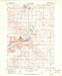
1967 Map of Chandler
USGS Topo · Published 1969About this map
The prairie landscape of Murray County is defined here by the intersection of rail and water, centered on the communities of Lake Wilson and Chandler. Surveyed in the late 1960s, the map reveals an agricultural region shaped by the Chicago and North Western and the Chicago Milwaukee St Paul and Pacific railroads. These transit lines connected the rural townships of Chanarambie, Leeds, Moulton, and Fenton to wider markets.
Find a feature on this map
24 named features on this map. Tap any name to fly to it.
Don’t see what you’re looking for? This feature index may not catch every label — zoom into the map to look around manually.
Map Details
Editions of this 1967 Chandler Map
This is the sole edition of this map. No revisions or reprints were ever made.
Other maps of this area

1953 · Watertown
USGS Topo · 1:250,000

1953 · New Ulm
USGS Topo · 1:250,000

1954 · Fairmont
USGS Topo · 1:250,000

1955 · Sioux Falls
USGS Topo · 1:250,000

1957 · New Ulm
USGS Topo · 1:250,000

1958 · New Ulm
USGS Topo · 1:250,000

1958 · Sioux Falls
USGS Topo · 1:250,000

1958 · Fairmont
USGS Topo · 1:250,000

1958 · Watertown
USGS Topo · 1:250,000

1967 · New Ulm
USGS Topo · 1:250,000