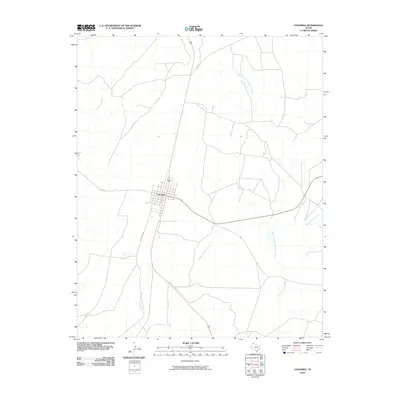
2010 Map of Channing
USGS Topo · Published 2010About this map
Channing serves as the primary hub of this High Plains landscape, situated at the junction of several key regional routes including FM 767 and FM 722. The settlement pattern reflects the open ranching and agricultural character of Hartley County, where long-distance roads like Quin Saber Rd stretch across the plateau. The hydrology is defined by an intricate network of seasonal drainages, specifically the various branches of the Cheyenne Creek system. This includes the convergence of West Cheyenne Creek, Middle Cheyenne Creek, and East Cheyenne Creek, alongside the more northerly West Fork East Cheyenne Creek. In the western portion of the quadrangle, the terrain is further shaped by the course of Los Redos Creek. These waterways, while often dry, dictate the historical movement and land use across this part of the Texas Panhandle.
Find a feature on this map
9 named features on this map. Tap any name to fly to it.
Don’t see what you’re looking for? This feature index may not catch every label — zoom into the map to look around manually.
Map Details
Editions of this 2010 Channing Map
This is the sole edition of this map. No revisions or reprints were ever made.
Other maps of this area

1954 · Tucumcari
USGS Topo · 1:250,000

1958 · Tucumcari
USGS Topo · 1:250,000

1963 · Hartley SE
USGS Topo · 1:24,000

1963 · Bird Ranch Store
USGS Topo · 1:24,000

1971 · Bivins Channing Ranch
USGS Topo · 1:24,000

1971 · Channing NW
USGS Topo · 1:24,000

1971 · Boys Ranch West
USGS Topo · 1:24,000
1971 · Boys Ranch East
USGS Topo · 1:24,000
1971 · Torrey House
USGS Topo · 1:24,000
1971 · Channing
USGS Topo · 1:24,000