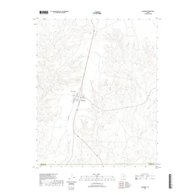
2019 Map of Channing
USGS Topo · Published 2019About this map
Channing serves as a focal point of this High Plains landscape, situated just north of the Hartley Co Oldham Co boundary. The town's grid is defined by street names that reflect the region's railroad history, such as Santa Fe Ave, Rock Island Ave, and Denver Ave. This 2019 survey documents the modern street layout and the position of the Channing Cem north of the residential center. The surrounding terrain is heavily dissected by complex drainage networks, including Middle Cheyenne Cr, E Cheyenne Cr, and W Cheyenne Cr. These seasonal watercourses carve through the landscape, illustrating the dramatic erosional patterns typical of this part of the Texas Panhandle. Beyond the town limits, the map traces arterial routes like FM 722 and FM 767, which connect this remote settlement to the broader region.
Find a feature on this map
19 named features on this map. Tap any name to fly to it.
Don’t see what you’re looking for? This feature index may not catch every label — zoom into the map to look around manually.
Map Details
Editions of this 2019 Channing Map
This is the sole edition of this map. No revisions or reprints were ever made.
Other maps of this area

1954 · Tucumcari
USGS Topo · 1:250,000

1958 · Tucumcari
USGS Topo · 1:250,000

1963 · Hartley SE
USGS Topo · 1:24,000

1963 · Bird Ranch Store
USGS Topo · 1:24,000

1971 · Bivins Channing Ranch
USGS Topo · 1:24,000

1971 · Channing NW
USGS Topo · 1:24,000

1971 · Boys Ranch West
USGS Topo · 1:24,000
1971 · Boys Ranch East
USGS Topo · 1:24,000
1971 · Torrey House
USGS Topo · 1:24,000
1971 · Channing
USGS Topo · 1:24,000