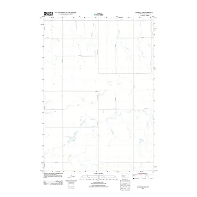
2012 Map of Chapelle Lake
USGS Topo · Published 2012About this map
Chapelle Lake and its surrounding prairie landscape define this section of South Dakota, where the water table and natural drainages dictate the local geography. The winding course of Chapelle Cr meanders across the southern half of the quadrangle, carving a distinct path through the grid of section lines. This survey shows a highly structured rural transport network typical of the Great Plains, where the landscape is organized by an exacting grid of roads such as 327th Ave and 199th St. The presence of the Holabird Grade indicates a legacy of planned infrastructure and historic movement through this portion of Hyde County. For those researching the environmental history of the region, the map documents the seasonal water bodies and intermittent streams that characterize the territory between 200th St and the southern boundary at 207th St.
Find a feature on this map
17 named features on this map. Tap any name to fly to it.
Don’t see what you’re looking for? This feature index may not catch every label — zoom into the map to look around manually.
Map Details
Editions of this 2012 Chapelle Lake Map
This is the sole edition of this map. No revisions or reprints were ever made.
Other maps of this area

1950 · Highmore
USGS Topo · 1:24,000

1953 · Huron
USGS Topo · 1:250,000

1954 · Huron
USGS Topo · 1:250,000

1968 · Harrold
USGS Topo · 1:24,000

1968 · Holabird
USGS Topo · 1:24,000

1973 · Chapelle Lake SE
USGS Topo · 1:24,000

1973 · Chapelle Lake SW
USGS Topo · 1:24,000

1973 · Chapelle Lake
USGS Topo · 1:24,000

1973 · Macs Corner
USGS Topo · 1:24,000
1973 · Macs Corner NW
USGS Topo · 1:24,000