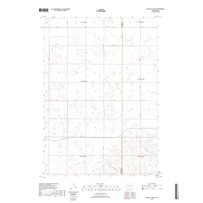
2017 Map of Chapelle Lake SW
USGS Topo · Published 2017About this map
Hydrological patterns and section-line roads define this high plains landscape along the Hughes County and Hyde County line. The map captures a topography marked by ephemeral watercourses like S Chapelle Cr in the north and Joe Cr in the southwest, draining into a complex system of prairie potholes and seasonal wetlands. The southern reaches are characterized by the winding path of Chaney Rush Cr, which is shadowed by the rural transit of Chaney Rush Rd. This 2017 survey reflects the persistent agricultural grid system of the Big Bend District, where major thoroughfares like 214th St and Co Rd 200 facilitate movement across the sparsely populated interior. The distribution of small water bodies across the central townships suggests the essential role of surface water management in this cattle-ranching region of central South Dakota.
Find a feature on this map
21 named features on this map. Tap any name to fly to it.
Don’t see what you’re looking for? This feature index may not catch every label — zoom into the map to look around manually.
Map Details
Editions of this 2017 Chapelle Lake SW Map
This is the sole edition of this map. No revisions or reprints were ever made.
Other maps of this area
1953 · Huron
USGS Topo · 1:250,000
1954 · Huron
USGS Topo · 1:250,000
1966 · Lower Brule NW
USGS Topo · 1:24,000
1966 · Joe Creek
USGS Topo · 1:24,000
1966 · Lower Brule NE
USGS Topo · 1:24,000
1967 · De Grey NE
USGS Topo · 1:24,000
1973 · Chapelle Lake SE
USGS Topo · 1:24,000
1973 · De Grey SE
USGS Topo · 1:24,000
1973 · Chapelle Lake SW
USGS Topo · 1:24,000
1973 · Chapelle Lake
USGS Topo · 1:24,000