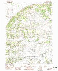
1983 Map of Chapin
USGS Topo · Published 1983About this map
Chapin serves as a central hub on this 1980s landscape, situated at the junction of the Burlington Northern and Norfolk and Western railroads. This intersection in Morgan County highlights the transit-driven layout of rural Illinois settlements, with the village of Bethel and the smaller site of Neelyville positioned along these vital rail corridors. The surrounding terrain is defined by a series of south-flowing drainages, including Coon Run and Eagle Run, which have carved distinctive valleys through the farmland.
Find a feature on this map
28 named features on this map. Tap any name to fly to it.
Don’t see what you’re looking for? This feature index may not catch every label — zoom into the map to look around manually.
Map Details
Editions of this 1983 Chapin Map
This is the sole edition of this map. No revisions or reprints were ever made.
Other maps of this area

1924 · Winchester
USGS Topo · 1:48,000

1924 · Griggsville
USGS Topo · 1:62,500

1926 · Griggsville
USGS Topo · 1:62,500

1926 · Winchester
USGS Topo · 1:62,500

1928 · Meredosia
USGS Topo · 1:62,500

1929 · Arenzville
USGS Topo · 1:62,500

1931 · Meredosia
USGS Topo · 1:62,500

1932 · Arenzville
USGS Topo · 1:62,500

1948 · Quincy
USGS Topo · 1:250,000

1956 · Quincy
USGS Topo · 1:250,000