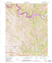
1972 Map of Chaplin
USGS Topo · Published 1987About this map
Taylorsville Lake dominates the northern reaches of this landscape, its waters filling the deep valleys of the Salt River and its many tributaries like Timber Creek and Ashes Creek. This 1970s revision, later edited in 1987, documents the significant topographical change brought by the reservoir, while still preserving the underlying rural character of the region. Local landmarks such as Mitchell Hill and Pleasant Grove Ridge rise above the intricate drainage network, providing a clear view of the complex terrain that defines the borders of Spencer, Nelson, and Anderson counties.
Find a feature on this map
32 named features on this map. Tap any name to fly to it.
Don’t see what you’re looking for? This feature index may not catch every label — zoom into the map to look around manually.
Map Details
Editions of this 1972 Chaplin Map
2 editions found
Other maps of this area

1923 · Waddy
USGS Topo · 1:48,000

1925 · Mount Eden
USGS Topo · 1:48,000

1927 · Mount Eden
USGS Topo · 1:62,500

1929 · Taylorsville
USGS Topo · 1:62,500

1952 · Ashbrook
USGS Topo · 1:24,000

1952 · Chaplin
USGS Topo · 1:24,000

1953 · Brush Grove
USGS Topo · 1:24,000

1953 · Maud
USGS Topo · 1:24,000

1953 · Cardwell
USGS Topo · 1:24,000

1953 · Bloomfield
USGS Topo · 1:24,000