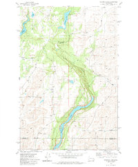
1980 Map of Chapman Lake
USGS Topo · Published 1981About this map
Bonnie Lake and Chapman Lake anchor this 1980 survey of the Scablands terrain south of Cheney, where the landscape is defined by the carved basalt coulees of the Rock Creek drainage. A notable historical waypoint is marked by the Capt J Mullan Historical Mon along the old wagon route through the coulee, commemorating the road-building efforts of the mid-19th century. The map detail highlights the sparse settlement of the region, where rural life revolved around the complex hydrology of the lakes and seasonal springs. Evidence of the area's geological and human history is etched into the terrain, from the Buckeye junction along Rock Creek to the various gravel and borrow pits that supported local infrastructure. The transition from Spokane County into Whitman County is captured at the southern edge, crossing the finger-like extension of Bonnie Lake.
Find a feature on this map
29 named features on this map. Tap any name to fly to it.
Don’t see what you’re looking for? This feature index may not catch every label — zoom into the map to look around manually.
Map Details
Editions of this 1980 Chapman Lake Map
This is the sole edition of this map. No revisions or reprints were ever made.
Other maps of this area

1903 · Oakesdale
USGS Topo · 1:125,000

1905 · Oakesdale
USGS Topo · 1:125,000

1954 · Cheney
USGS Topo · 1:62,500

1954 · Spangle
USGS Topo · 1:62,500

1955 · Spokane
USGS Topo · 1:250,000

1958 · Spokane
USGS Topo · 1:250,000

1964 · Malden
USGS Topo · 1:24,000

1964 · Rock Lake
USGS Topo · 1:24,000

1964 · Pine City
USGS Topo · 1:24,000
1980 · Spangle West
USGS Topo · 1:24,000