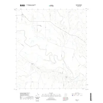
2019 Map of Charco
USGS Topo · Published 2019About this map
The settlement of Charco anchors this rural landscape in Goliad County, where the terrain is deeply shaped by the winding course of the San Antonio River. The land here is defined by a network of drainage systems, including Charco Cr, Cabeza Cr, and Hord Cr, which carve through the south Texas countryside. Significant for genealogists, the map preserves the locations of several family-named burial grounds, such as the Smith-Walker Cemetery, John Pettus Cem, and Lott Pettus Cem, alongside the San Jasinto Cem. These landmarks, often situated near farm roads like John Pettis Rd and Irby Rd, point to the region's agricultural and ranching heritage. Transportation and utility are marked by the Lantana Ridge Airport and the crossroads formed by FM 81 and FM 1351, illustrating the area's modern infrastructure within its traditional cattle-country context.
Find a feature on this map
28 named features on this map. Tap any name to fly to it.
Don’t see what you’re looking for? This feature index may not catch every label — zoom into the map to look around manually.
Map Details
Editions of this 2019 Charco Map
This is the sole edition of this map. No revisions or reprints were ever made.
Other maps of this area

1953 · Beeville
USGS Topo · 1:250,000

1956 · Beeville
USGS Topo · 1:250,000

1960 · Beeville
USGS Topo · 1:250,000

1962 · Melo
USGS Topo · 1:24,000

1962 · Goliad
USGS Topo · 1:24,000
1963 · Choate
USGS Topo · 1:24,000

1963 · Lazy F Ranch
USGS Topo · 1:24,000

1963 · Weesatche
USGS Topo · 1:24,000
1963 · Berclair NW
USGS Topo · 1:24,000

1963 · Berclair
USGS Topo · 1:24,000