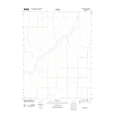
2012 Map of Chardon NW
USGS Topo · Published 2012About this map
Beaver Cr winds through the northwestern reaches of Rawlins County, defining the primary drainage pattern for this section of the High Plains. The landscape is characterized by its broad agricultural grid and the subtle incisions made by watercourses like N Fork Sappa Cr in the southern portion of the sheet. Modern infrastructure is represented by a network of county thoroughfares, including Co Rd 407, Co Rd 414, and Co Rd 417, which provide access to the rural farmsteads and fields that dominate the terrain. This 2012 survey captures the enduring rural character of the region, where the section-line roads and seasonal creeks remain the primary landmarks for local residents and land managers.
Find a feature on this map
5 named features on this map. Tap any name to fly to it.
Don’t see what you’re looking for? This feature index may not catch every label — zoom into the map to look around manually.
Map Details
Editions of this 2012 Chardon NW Map
This is the sole edition of this map. No revisions or reprints were ever made.
Other maps of this area
1950 · Mc Donald
USGS Topo · 1:62,500
1951 · Mc Donald
USGS Topo · 1:62,500
1951 · Atwood
USGS Topo · 1:62,500
1951 · Chardon
USGS Topo · 1:62,500
1951 · Dewey Ranch
USGS Topo · 1:62,500

1954 · Goodland
USGS Topo · 1:250,000

1956 · Goodland
USGS Topo · 1:250,000

1957 · Goodland
USGS Topo · 1:250,000
1978 · Beardsley
USGS Topo · 1:24,000
1978 · Atwood
USGS Topo · 1:24,000