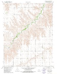
1981 Map of Chardon NW
USGS Topo · Published 1981About this map
Beaver Creek winds through the northern plains of Rawlins County, defining a landscape of agricultural boundaries and rural infrastructure as it appeared in the late 1970s. The territory is organized into townships including Celia, Logan, Mikesell, and Mirage, reflecting the systematic settlement patterns of Western Kansas. Rural life is anchored by Stevens Chapel in the southeast, while the economy is marked by several extractive sites such as a Sandpit and Gravel Pit. To the south, the North Fork Sappa Creek carves a secondary drainage through Grant township. This topographic study, based on 1977 aerial photography, documents a network of section lines, windmills, and isolated farmsteads typical of the High Plains before modern agricultural consolidation significantly altered the small-scale field patterns visible here.
Find a feature on this map
10 named features on this map. Tap any name to fly to it.
Don’t see what you’re looking for? This feature index may not catch every label — zoom into the map to look around manually.
Map Details
Editions of this 1981 Chardon NW Map
This is the sole edition of this map. No revisions or reprints were ever made.
Other maps of this area

1950 · Mc Donald
USGS Topo · 1:62,500

1951 · Mc Donald
USGS Topo · 1:62,500

1951 · Atwood
USGS Topo · 1:62,500

1951 · Chardon
USGS Topo · 1:62,500

1951 · Dewey Ranch
USGS Topo · 1:62,500

1954 · Goodland
USGS Topo · 1:250,000

1956 · Goodland
USGS Topo · 1:250,000

1957 · Goodland
USGS Topo · 1:250,000
1978 · Beardsley
USGS Topo · 1:24,000
1978 · Atwood
USGS Topo · 1:24,000