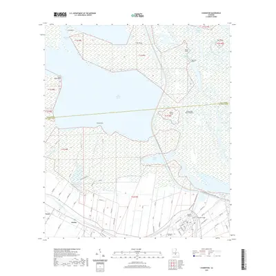
2020 Map of Charenton
USGS Topo · Published 2020About this map
Bayou Teche winds through the southern portion of this landscape, anchoring a corridor of historical settlements including Sorrel, Matilda, and Indian Bend. The region is defined by its complex relationship with water, where the managed Atchafalaya Basin Floodway and the Charenton Drainage and Navigation Canal interface with the open waters of Lake Fausse Pointe and Grand Avoille Cove. Inland, the agricultural and residential layout is marked by family-named roads such as Beggie Ln and Banta Leisel Ln. This modern survey illustrates the persistent importance of the Chitimacha tribal community, evidenced by the Chitimacha Air Park and streets like Chitimacha Trl. The transition between Iberia and St. Mary Parishes is clearly delineated, showing how contemporary infrastructure like Hwy 90 and the Charenton Bridge maintains connectivity across these historic wetlands and the W Atchafalaya Basin Spillway Levee.
Find a feature on this map
62 named features on this map. Tap any name to fly to it.
Don’t see what you’re looking for? This feature index may not catch every label — zoom into the map to look around manually.
Map Details
Editions of this 2020 Charenton Map
This is the sole edition of this map. No revisions or reprints were ever made.
Other maps of this area

1935 · Chicot Lake
USGS Topo · 1:62,500

1937 · Jeanerette
USGS Topo · 1:62,500

1941 · Loreauville
USGS Topo · 1:62,500

1945 · New Orleans
USGS Topo · 1:250,000

1948 · Foster
USGS Topo · 1:62,500

1954 · Chicot Lake
USGS Topo · 1:62,500

1954 · Loreauville
USGS Topo · 1:62,500

1954 · Jeanerette
USGS Topo · 1:62,500

1954 · Baton Rouge
USGS Topo · 1:250,000
1955 · Chicot Lake
USGS Topo · 1:62,500