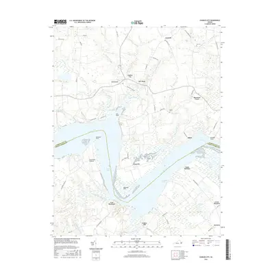
2016 Map of Charles City
USGS Topo · Published 2016About this map
James River bends and reaches dominate this coastal Virginia landscape, where the historic Charles City sits as a central hub. The map highlights a series of significant landed estates and colonial-era settlements along the riverbanks, including Sherwood Forest, Weyanoke, and the sprawling grounds of Upper Brandon and Lower Brandon. These sites, alongside Flowerdew Hundred, represent the deep-rooted plantation and agricultural history of the region. On the southern bank, the prominent site of Fort Powhatan overlooks Threemile Reach, marking a strategic point of defense and observation along the water. Further inland, smaller communities such as Ruthville and New Hope are connected by a network of rural roads like Lott Cary Rd and Ruthville Rd. The drainage patterns of Mapsico Creek and Kittewan Creek define the low-lying wetlands and marshes that characterize the tidewater terrain between these historic outposts.
Find a feature on this map
64 named features on this map. Tap any name to fly to it.
Don’t see what you’re looking for? This feature index may not catch every label — zoom into the map to look around manually.
Map Details
Editions of this 2016 Charles City Map
This is the sole edition of this map. No revisions or reprints were ever made.
Other maps of this area

1917 · Toano
USGS Topo · 1:62,500

1918 · Charles City
USGS Topo · 1:62,500

1918 · Toano
USGS Topo · 1:62,500

1919 · Surry
USGS Topo · 1:62,500

1919 · Disputanta
USGS Topo · 1:62,500

1943 · Savedge
USGS Topo · 1:31,680

1943 · Disputanta
USGS Topo · 1:31,680

1943 · Richmond
USGS Topo · 1:250,000

1949 · Richmond
USGS Topo · 1:250,000
1952 · Brandon
USGS Topo · 1:24,000