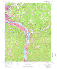
1958 Map of Charleston East
USGS Topo · Published 1978About this map
The Kanawha River serves as the industrial and transportation backbone for this area east of Charleston, where the river valley is tightly packed with infrastructure. While the city's urban core occupies the western edge, the valley floor to the southeast is a dense corridor of rail lines like the Conrail and Chesapeake and Ohio, alongside manufacturing centers such as Dupont City. The map reveals the era's mid-century development patterns, from the expansive Kanawha Airport atop the plateau to the growing residential footprints of Kanawha Estates and Port Amherst.
Find a feature on this map
103 named features on this map. Tap any name to fly to it.
Don’t see what you’re looking for? This feature index may not catch every label — zoom into the map to look around manually.
Map Details
Editions of this 1958 Charleston East Map
This is the sole edition of this map. No revisions or reprints were ever made.
Other maps of this area

1897 · Kanawha Falls
USGS Topo · 1:125,000

1899 · Charleston
USGS Topo · 1:125,000

1900 · Kanawha Falls
USGS Topo · 1:125,000

1901 · Kanawha Falls
USGS Topo · 1:125,000

1907 · Clendenin
USGS Topo · 1:62,500

1908 · Montgomery
USGS Topo · 1:48,000

1909 · Charleston
USGS Topo · 1:62,500

1909 · Clendenin
USGS Topo · 1:62,500

1909 · Peytona
USGS Topo · 1:48,000

1910 · Montgomery
USGS Topo · 1:62,500