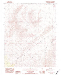
1984 Map of Charleston Peak NE
USGS Topo · Published 1984About this map
Desert View Natural Environment Area dominates this high-altitude landscape in Clark County, where the Spring Mountains terrain transitions through steep relief. This 1984 provisional survey illustrates a rugged topography defined by the drainage systems of Lee Canyon and Deer Creek. The map records specific land use and environmental management patterns from the early 1980s, including a localized Barrow Pit near the eastern margin. The intricate contour work reflects the specialized mapping efforts of the U.S. Geological Survey to document this protected natural environment, providing a technical baseline for the area just before significant regional growth began in the surrounding Nevada desert.
Find a feature on this map
7 named features on this map. Tap any name to fly to it.
Don’t see what you’re looking for? This feature index may not catch every label — zoom into the map to look around manually.
Map Details
Editions of this 1984 Charleston Peak NE Map
2 editions found
Other maps of this area

1907 · Las Vegas
USGS Topo · 1:250,000

1908 · Las Vegas
USGS Topo · 1:250,000

1942 · Indian Spring
USGS Topo · 1:125,000

1945 · Sheep Range
USGS Topo · 1:125,000

1952 · Corn Creek Springs
USGS Topo · 1:62,500

1954 · Las Vegas
USGS Topo · 1:250,000

1957 · Las Vegas
USGS Topo · 1:250,000

1957 · Charleston Peak
USGS Topo · 1:62,500

1959 · Las Vegas
USGS Topo · 1:250,000

1962 · Las Vegas
USGS Topo · 1:250,000