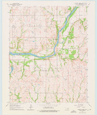
1963 Map of Charley Creek
USGS Topo · Published 1976About this map
The Arkansas River serves as the primary geographical divider on this 1960s landscape, marking the border between Kay and Osage Counties. This era is defined by intensive petroleum development, with the Hardy Oil Field, North Drum Oil Field, and Big Bend Oil Field dominating the southern half of the sheet. Numerous individual Oil Wells and storage tanks are scattered across the terrain, illustrating the industrial footprint of the mid-century energy boom in northern Oklahoma.
Find a feature on this map
28 named features on this map. Tap any name to fly to it.
Don’t see what you’re looking for? This feature index may not catch every label — zoom into the map to look around manually.
Map Details
Editions of this 1963 Charley Creek Map
4 editions found
Other maps of this area

1935 · Kaw
USGS Topo · 1:62,500

1936 · Belford
USGS Topo · 1:62,500

1955 · Enid
USGS Topo · 1:250,000

1958 · Enid
USGS Topo · 1:250,000

1963 · Charley Creek
USGS Topo · 1:24,000

1963 · Uncas
USGS Topo · 1:24,000

1964 · Charley Creek NE
USGS Topo · 1:24,000

1964 · Kaw City
USGS Topo · 1:24,000

1968 · Ponca City SE
USGS Topo · 1:24,000

1968 · Kildare
USGS Topo · 1:24,000