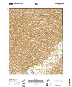
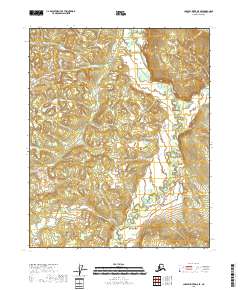
2018 Map of Charley River D-5 NW
USGS Topo · Published 2018About this map
Paddle Creek meanders through the southern portion of this high-latitude terrain, crossing through multiple townships including t12n r21e and t12n r20e. The landscape is defined by its dramatic topographic relief, where the North American Vertical Datum of 1988 captures a series of rounded summits and deep drainage basins typical of the Alaska interior. While the region is characterized by an absence of named settlements or man-made structures, the precise surveying of township and range lines provides a structural grid for understanding this portion of the Charley River region. The mapping of Paddle Creek and its unnamed tributaries reflects the complex hydrological patterns that shape the local valleys, offering a primary point of reference for navigators and researchers studying the drainage systems north of the 65th parallel.
Find a feature on this map
7 named features on this map. Tap any name to fly to it.
Don’t see what you’re looking for? This feature index may not catch every label — zoom into the map to look around manually.
Map Details
Editions of this 2018 Charley River D-5 NW Map
This is the sole edition of this map. No revisions or reprints were ever made.
Other maps of this area

1951 · Charley River
USGS Topo · 1:250,000

1951 · Black River
USGS Topo · 1:250,000

1956 · Black River A-6
USGS Topo · 1:63,360
1956 · Black River A-5
USGS Topo · 1:63,360
1956 · Charley River D-5
USGS Topo · 1:63,360

1956 · Black River
USGS Topo · 1:250,000
1956 · Charley River D-6
USGS Topo · 1:63,360

1956 · Charley River
USGS Topo · 1:250,000

1964 · Black River
USGS Topo · 1:250,000
2018 · Charley River D-5 SE
USGS Topo · 1:25,000