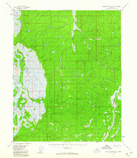
1956 Map of Charley River D-6
USGS Topo · Published 1960About this map
The Yukon River dominates the western edge of this 1950s interior Alaska landscape, weaving through a complex network of wetlands and sloughs. This mid-century survey illustrates the vast, unpopulated terrain of the Charley River region during an era of intensifying aerial photogrammetry by the Geological Survey. Small watercourses like Jefferson Creek and Big Creek drain the higher ground to the east, feeding into the river system. Evidence of human presence is remarkably sparse, limited to a single mapped cabin situated in the western lowlands, likely serving as a waypoint for hunters or travelers in the Alaskan interior. The eastern portion of the map is defined by the headwaters of Paddle Creek, where the terrain rises from the river valley into a series of rolling, unnamed hills and ridges.
Find a feature on this map
5 named features on this map. Tap any name to fly to it.
Don’t see what you’re looking for? This feature index may not catch every label — zoom into the map to look around manually.
Map Details
Editions of this 1956 Charley River D-6 Map
2 editions found
Other maps of this area

1951 · Fort Yukon
USGS Topo · 1:250,000

1951 · Charley River
USGS Topo · 1:250,000

1951 · Black River
USGS Topo · 1:250,000

1951 · Circle
USGS Topo · 1:250,000

1955 · Circle D-1
USGS Topo · 1:63,360

1955 · Circle C-1
USGS Topo · 1:63,360

1955 · Circle
USGS Topo · 1:250,000

1956 · Fort Yukon A-1
USGS Topo · 1:63,360

1956 · Black River A-6
USGS Topo · 1:63,360
1956 · Black River A-5
USGS Topo · 1:63,360