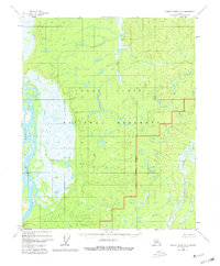
1956 Map of Charley River D-6
USGS Topo · Published 1980About this map
Yukon Flats characterizes the landscape of this 1950s survey, representing a vast interior Alaskan basin defined by its complex network of seasonal wetlands and meandering waterways. The map illustrates a period of administrative transition, marked by the prominent National Monument Boundary which delineates the Yukon Flats National Monument. This area, primarily unsurveyed and unmarked at the time of the original 1956 field annotation, reveals the primitive infrastructure of the northern wilderness, including a solitary Cabin situated in the western reaches. Drainage patterns are meticulously captured through named features like Big Creek, Jefferson Creek, and Paddle Creek, which feed into the broader river system. These hydrographic details reflect the land as it existed before minor revisions in 1979, providing a baseline for understanding the environmental and jurisdictional history of this remote subarctic region.
Find a feature on this map
8 named features on this map. Tap any name to fly to it.
Don’t see what you’re looking for? This feature index may not catch every label — zoom into the map to look around manually.
Map Details
Editions of this 1956 Charley River D-6 Map
2 editions found
Other maps of this area

1951 · Fort Yukon
USGS Topo · 1:250,000

1951 · Charley River
USGS Topo · 1:250,000

1951 · Black River
USGS Topo · 1:250,000

1951 · Circle
USGS Topo · 1:250,000

1955 · Circle D-1
USGS Topo · 1:63,360

1955 · Circle C-1
USGS Topo · 1:63,360

1955 · Circle
USGS Topo · 1:250,000

1956 · Fort Yukon A-1
USGS Topo · 1:63,360

1956 · Black River A-6
USGS Topo · 1:63,360
1956 · Black River A-5
USGS Topo · 1:63,360